
Oct. 18, 2026, 6:03 a.m. ET
One of El Niño’s most dramatic effects is waiting in the wings and could soon cause chaos along the West Coast, especially in California, forecasters warned.
A historic El Niño is expected to up the intensity of atmospheric rivers – long corridors of water vapor in the atmosphere that can transport tremendous amounts of moisture and produce heavy rain or snow when they reach land.
“A stronger El Niño brings stronger atmospheric rivers,” Daniel Swain, a climate scientist with the University of California Agriculture and Natural Resources, told USA TODAY. “There aren’t necessarily more of them, but atmospheric rivers are more intense during a strong El Niño like this one.”
In addition, strong El Niños also increase the frequency of non-atmospheric river storms in California, he said.

“Amid an El Niño that will become the strongest, and also easternmost-centered, event on record (if it isn’t already), this year’s tilt in the odds toward wet and stormy conditions in California will be profoundly unsubtle,” Swain wrote this week on his blog Weather West.
What are atmospheric rivers?
Often in the winter, you’ll hear that “atmospheric rivers” are causing big weather problems along the West Coast. But what are they?
Made visible by clouds, these ribbons of water vapor extend thousands of miles from the tropics to the western U.S. At 250 to 375 miles wide, they provide the fuel for massive rain and snowstorms that can cause flooding along the West Coast.
In general, atmospheric rivers pick up water vapor from the warm, moist air of tropical regions and then drop the water over land in cooler regions as rain or snow.
These “rivers in the sky” are responsible for up to 65% of the western USA’s extreme rain and snow events, a 2017 study said. And on average, up to 50% of the annual precipitation on the West Coast occurs in just a few atmospheric river events.
Some atmospheric rivers can stretch as far as 5,000 miles, all the way from Asia.
Though beneficial for water supplies, such events can wreak havoc on travel, bring deadly mudslides and cause catastrophic damage to life and property, the National Oceanic and Atmospheric Administration said.

When will the atmospheric rivers begin?
“It’s impossible to predict, but I’ll be surprised if we see anything in October,” Swain said.
AccuWeather’s Alex DaSilva told USA TODAY that “we can see the first one as early as mid-November. The time of year when they will be the most frequent will be in January and February.”

Has El Niño already brought extreme weather to the West?
Even before the “atmospheric river” season begins in a few weeks, remnants from an eastern Pacific hurricane (Rachel) already brought flooding to Southern California and the Southwest earlier this month.
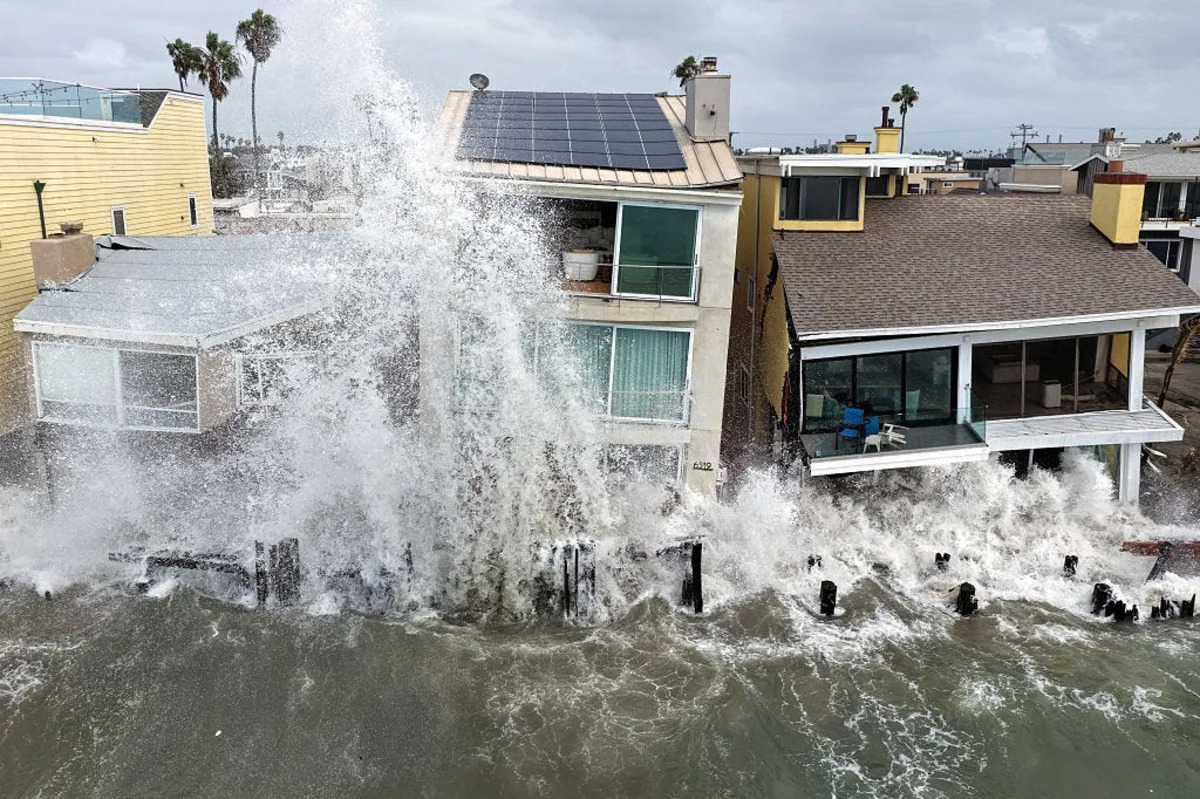
In California, several days of high tides, coastal surge and winds battered and damaged homes along the Long Beach Peninsula and flooded Newport Beach’s Balboa Peninsula, AccuWeather reports.
Elsewhere, heavy rainfall caused flash flooding and closed dozens of roads from San Diego County through the Coachella and Imperial valleys to Kingman and southern Utah. Record rainfall overwhelmed desert land in Las Vegas, which recorded its wettest October day, leading to dozens of water rescues.
Rachel can partially be attributed to El Niño, DaSilva told USA TODAY via e-mail: “El Niños typically bring less wind shear (hostile winds) across the Pacific basin, so there was less wind shear that the storm had to contend with. Less wind shear overall allowed the storm to survive longer than if the environment was more hostile.
“Sea-surface temperatures off of California were also well above average. This isn’t always the case in El Niño years, but this year it was very much the case,” DaSilva said.
Hurricane season still a worry
Experts continue to warn that intensifying El Niño conditions will continue to produce tropical activity in the Pacific and drive rain and potentially more storms into the West Coast.
“The Pacific is expected to remain active for the rest of the hurricane season and could send organized storms and moisture into the coastline,” said DaSilva. “As we move into the winter months, powerful atmospheric rivers become a threat, and we’re forecasting a wet and even snowy winter across the area.”
Does fall weather predict winter weather?
Apparently, no: There remains “little physical or statistical connection between autumn (Sept.-Nov.) precipitation and even an extremely strong El Niño event,” according to Swain, writing in Weather West: “Do not be surprised if October, and even November, are fairly unremarkable with respect to storm activity in California and the Southwest; it could be wet, it could be dry, and right now there’s just not much signal either way.
“But what happens this autumn has no bearing whatsoever on what is increasingly likely to occur this coming winter.”
How concerned should Californians be about this winter’s El Niño?
“I think Californians should be concerned this winter about additional beach erosion,” DaSilva told USA TODAY. “Several storms this season have produced significant erosion, and this may continue with powerful atmospheric rivers this winter.
“We also need to be concerned with strong winds and flooding rains with these atmospheric rivers. I think there can be a couple of very strong atmospheric rivers that can cause some pretty significant flooding. We can also see flooding from snow melting as temperatures warm later in the spring months.”
Doyle Rice is a national correspondent for USA TODAY, with a focus on weather and climate.








Leave a Reply