
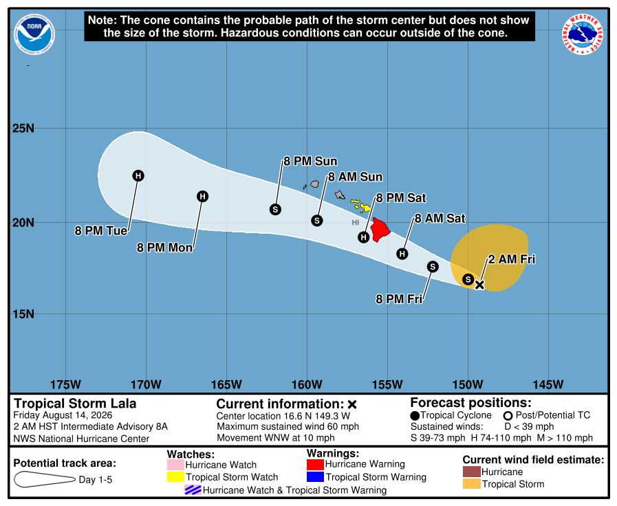
Tropical Storm Lala is picking up strength as it barrels toward Hawaii, according to the National Hurricane Center.
The storm is expected to reach hurricane status as it approaches the Big Island on Aug. 15, forecasters said, with a hurricane warning in effect for Hawaii County and a tropical storm watch in effect for Maui County.
Hawaii Gov. Josh Green declared a state of emergency ahead of the storm. He said impacts will come first to the Big Island before reaching other parts of the state, with winds getting “pretty serious” on Aug. 14.
“Please continue to be vigilant and look out for one another,” he said.
In an early morning advisory on Friday, Aug. 14, forecasters said Lala was about 650 miles east-southeast of Honolulu with maximum sustained winds near 60 mph with higher gusts. Forecasters said a general west-northwest motion is expected to continue, taking the “core of Lala near the Big Island of Hawaii on Saturday and then south of the smaller islands on Sunday.”
The NHC said “steady strengthening” is forecast for Lala as it approaches the Big Island, with hurricane conditions expected there by early Saturday morning and tropical storm conditions in Maui by late Saturday.
Lala is expected to produce rainfall totals of 8 to 12 inches across Maui and the Big Island, with a maximum of 25 inches possible across the Big Island. Totals of 4 to 6 inches, with maximum totals around 8 inches, are possible across the remainder of the island chain.
NHC forecasters also said in the advisory that the combination of a dangerous storm surge and the tide will cause normally dry areas near the coast to be flooded by rising waters moving inland from the shoreline. Swells generated by Lala are also expected to reach the east-facing shores Friday, spreading westward and building through the weekend.
These swells are likely to cause “life-threatening” surf and rip current conditions, forecasters said.
Tropical Storm Lala path tracker
This forecast track shows the most likely path of the center of the storm. It does not illustrate the full width of the storm or its impacts, and the center of the storm is likely to travel outside the cone up to 33% of the time.
Tropical Storm Lala spaghetti models
Illustrations include an array of forecast tools and models, and not all are created equal. The hurricane center uses only the top four or five highest-performing models to help make its forecasts.
Hurricane safety tips
As hurricane activity increases in both basins, experts say now is a good time for residents to review hurricane safety plans.
The National Weather Service notes that storm surge and inland flooding remain the deadliest hurricane hazards, and urged people to know their evacuation zone, follow evacuation orders and never drive on flooded roads. Several storm-related fatalities in 2026 have been linked to motorists attempting to cross flooded roadways.
The National Oceanic and Atmospheric Administration also recommends assembling an emergency kit that includes at least three days of water (1 gallon per person per day), nonperishable food, medications, flashlights, batteries, cash and a battery-powered or hand-cranked weather radio.
NOAA further advises having multiple ways to receive emergency warnings rather than relying solely on a cellphone. Options include weather radios, emergency alert systems, television and radio broadcasts, and trusted weather apps.
Contributing: Thao Nguyen & Jeanine Santucci, USA TODAY
Gabe Hauari is a national trending news reporter at USA TODAY. You can follow him on X @GabeHauari or email him at Gdhauari@usatoday.com.
This article originally appeared on USA TODAY: See Tropical Storm Lala tracker as storm approaches Hawaii











Leave a Reply