
After a relatively quiet start to the 2026 Atlantic hurricane season, a flurry of activity appeared in mid-August, but forecasters aren’t currently worried about major threats to the United States.
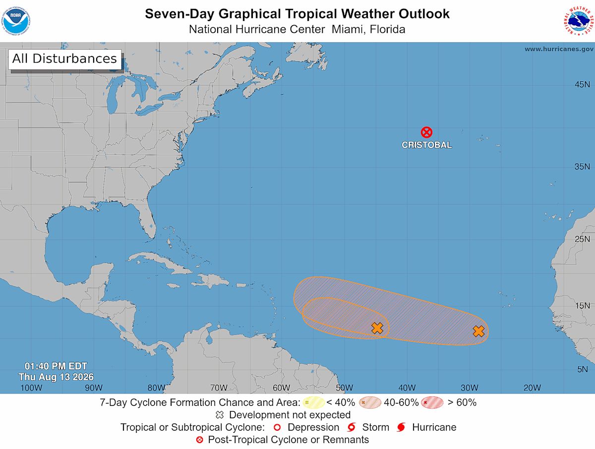
The Atlantic Ocean – under the increasing influence of El Niño’s winds and warming waters – sprang to life the week of August 9 with at least four tropical disturbances being monitored at once by the National Hurricane Center.
One of those disturbances quickly became Tropical Storm Cristobal then dissipated just as quickly as it moved away from the United States in open water between Bermuda and the Azores. Another area of disturbed weather also quickly fizzled.
Two other storms still bear watching, although neither poses a direct threat to the mainland United States at this time, thanks in great part to the strengthening El Niño along the equator off the coast of South America.

Waves are making their way off the African coast, but increasingly encountering unfavorable conditions in the western Atlantic, thanks to the shearing winds created by the El Niño.
While the season is less busy than normal in the Atlantic, the Pacific is seeing a much busier year because of the changing conditions from El Niño. The Pacific saw a burst of activity in mid-August with two storms being monitored, including Lala, which has threatened to make a direct hit on the Big Island in Hawaii.
The big player in both oceans is El Niño. The National Oceanic and Atmospheric Administration, parent agency to the Climate Prediction Center and the National Weather Service, warned on Aug. 13 that this El Niño event could be “historic.”
What’s next in the Atlantic?
The tropical disturbance the hurricane center has been watching between the Lesser Antilles and the west coast of Africa was moving westward on the morning of Aug. 12. While a “Hello Dolly!” headline seems like a fun idea, it’s looking more likely that this disturbance won’t get a name at all.
It’s forecast to become “a short-lived tropical depression” but its chances of that have been reduced as it faces shearing winds and dry air likely to shred it as it moves toward the Caribbean, according to the latest update from the hurricane center. Regardless of its status, interests in the Lesser Antilles still should monitor the weather for chances of gusty winds and heavy rain overnight on August 14 and into the next morning, the hurricane center said.
Meanwhile, a wave that moved off the western coast of Africa quickly caught the attention of the many models the center uses to make forecasts. On Aug. 13, that area of disturbed weather had a 30% chance of becoming a tropical depression over 48 hours and a 50% chance over seven days, the hurricane center said.
While the El Niño influence in the western Atlantic is forecast to limit the chances for tropical storms forming, any rain that makes it through might be beneficial to drought stricken areas in Puerto Rico and the Virgin Islands, meteorologists said this week.
Short-lived Cristobal
Tropical Storm Cristobal proved a bit of a surprise, snagging the spot as the season’s third tropical storm on Aug. 12, ahead of a developing system moving westward in the Atlantic that many had expected to be the third named storm.
Just 24 hours later, Cristobal had fizzled.
Why the sudden activity?
The peak of the Atlantic hurricane season typically takes place between mid-August and mid-October, so it’s no big surprise to see storms appearing in the region as mid-August arrives. This season has been decidedly quiet, especially compared to recent seasons that have been more active early. For example, the 2025 hurricane season had produced six named storms before Sept. 1.
Heat and moisture are two big reasons the late summer and early fall period tends to be most active period for storms. Tropical waves move off the west coast of Africa every few days, and as those waves move west over the ocean, they experience the least wind shear in mid- to late-August during a typical year, according to NOAA. It’s also the period when ocean temperatures have been increasing in the summer sun, and warm water helps to fuel storms.
However, this year isn’t typical by a long shot, primarily because of the powerful El Niño. That’s why recently updated 2026 seasonal outlooks continue to predict the season will be less active than recent seasons,
Why does El Niño batter Atlantic storms?
As temperatures warm, the winds over the Pacific widely influence weather across the globe. The phenomenon particularly creates strong winds over the Atlantic that suppress hurricanes and other storms by shearing off the tops and preventing the circulations from gaining the high cloud tops that are essential for stronger storms.
Water temperatures in the El Niño region of the Pacific have climbed for weeks, and many El Niño experts say the naturally occurring climate pattern could reach record strength later this year, becoming the strongest such event since at least the 1950s.
These signals from the El Niño are why seasonal forecast outlooks reduced the numbers of storms expected to form across the Atlantic basin this year.
The vertical average wind shear over the Atlantic is the strongest on record, even pulling ahead of the powerful El Niño of 2015, Phil Klotzbach, a senior research scientist at Colorado State University, stated in a social media post. El Niño has had “very strong imprints on this season already,” Klotzbach said.

Sea surface temperatures in the El Niño region have climbed this year, setting daily records for weeks, according to NOAA data, as an El Niño strengthens along the equator in the eastern Pacific.
Dinah Voyles Pulver, a national correspondent for USA TODAY, covers violent weather, climate and the environment, among other news. Reach her at dpulver@usatoday.com.
This article originally appeared on USA TODAY: Hurricane forecasters say there’s a flurry of activity in Atlantic











Leave a Reply